Within the manual Protocols for experimental plot sampling, handling and processing of cereals in field experiments![]() by G.J. Rebetzke (Greg.Rebetzke@csiro.au), A. van Herwaarden, B. Biddulph, C. Moeller, R. Richards, A. Rattey and K. Chenu.
by G.J. Rebetzke (Greg.Rebetzke@csiro.au), A. van Herwaarden, B. Biddulph, C. Moeller, R. Richards, A. Rattey and K. Chenu.
Good ground cover is important for intercepting light needed for growth, shading the soil to reduce soil evaporation, and for capacity of the crop to better compete with weeds.
Method
Ground cover assessments can be made from early emergence until approaching full canopy cover (usually around DC30). There are several methods commonly used:
- a. Digital camera: Photographs taken at approximately the same height (e.g. 1m, a tripod can be used) in representative parts of each plot can be downloaded for digital analysis of ground cover (Fig. 8). Free software (e.g. our photo processing software is available upon request) can distinguish between green and other colours including soil to calculate the area of the total image that is green. It is important that plots are reasonably free of weeds as this software cannot distinguish between crop and other plants. If the plot is variable for plant number or vigour then two photos should be taken for ground cover. A picture with a scale should be taken at least once or the row width used for scale.
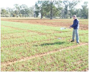
- b. Greenseeker meter: Instruments such as the Greenseeker chlorophyll sensor® provide a measure of plot greenness using the Normalised Difference Vegetation Index or NDVI. Calibration of the unit is quick, and assessment of ground cover and biomass may be achieved on many plots (see Fig. 9). Greenseeker NDVI scores correlate well with % ground cover and total biomass up to DC30 (Fig. 10a, b), but the strength of this relationship may vary with extreme stress. Importantly, the sensor must be directed towards to soil and maintained as approximately the same height for all plots – a harness is supplied with the unit to assist with this (Fig. 8).
- c. Light interception meter: See page 15
") .
.
- d. Visual score: Where no such electronic equipment is available, qualitative scores on a 1 – 9 scale (1 = no ground cover, 9 = highest ground cover) based on a visual observation should be given. During this process, it is best to use some known lines with high and low early vigour (e.g. Fig. 8) as a benchmark, and the same person should do the entire trial to retain relativity.
 |
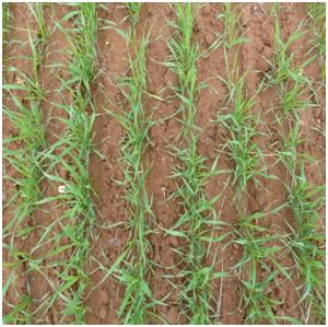 |
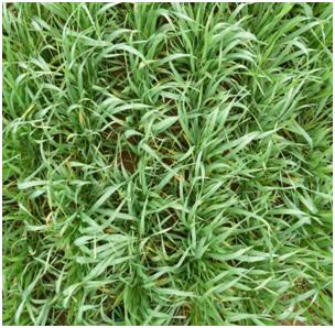
Figure 8. Vigorous (left) and less vigorous (right) wheat canopies. Images taken at 1m height. Ground cover (95% for left and 42% for right) was estimated from digital photos using ground cover processing software.
 |
 |
Figure 9. Calibration (left) and then scanning while walking (right) of wheat plots using a Greenseeker chlorophyll sensor.
 |
 |
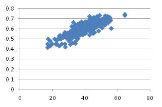
Figure 10. Relationship of: (a) % ground cover from a digital camera (x-axis) and NDVI using a Greenseeker chlorophyll sensor (y-axis) for a large number of wheat genotypes (r2 = 0.74, P<0.01); and (b) NDVI using a Greenseeker chlorophyll sensor (x-axis) and total plant biomass for 28 wheat genotypes (r2 = 0.90, P<0.01)
Other resources
Appendix 1.![]() Text description of phenological scale, Zadoks decimal code (DC).
Text description of phenological scale, Zadoks decimal code (DC).
Appendix 2.![]() Picture description of phenological scale, Zadoks decimal code (DC).
Picture description of phenological scale, Zadoks decimal code (DC).
Zadoks JC, Chang TT, Konzak CF (1974) A decimal code for the growth stages of cereals. Weed Research 14(6),415-421. doi: 10.1111/j.1365-3180.1974.tb01084.x
Notes and troubleshooting tips
Literature
Download complete manual: Protocols for cereal field experiments_Nov2012.pdf
Health, safety & hazardous waste disposal considerations